
Building Smarter Streets, Better Corridors and More Livable Cities
Urban mobility planning is the strategic process of designing how people and goods move through cities. It connects transportation, land use, public space, safety, accessibility and sustainability into one practical planning framework. A strong urban mobility plan does not only ask how traffic can move faster. It asks how streets can work better for people, businesses, public transport, walking, cycling, logistics and future mobility needs.
The European Commission defines a Sustainable Urban Mobility Plan as a strategic plan designed to meet the mobility needs of people and businesses in cities and surrounding areas while improving quality of life. It also emphasizes integration, participation and evaluation as core planning principles.
For municipalities, transportation engineers, urban planners and design teams, urban mobility planning has become a central part of creating safer, more efficient and more resilient cities. It is where policy becomes geometry, and where high-level mobility goals must be translated into street layouts, corridor sections, public realm decisions and clear design alternatives.
What Is Urban Mobility Planning?
Urban mobility planning is the professional discipline of organizing movement within an urban area. It includes public transport, walking, cycling, private vehicles, freight, shared mobility, curb management, accessibility, safety, parking and the relationship between transport infrastructure and land use.
A modern urban mobility plan usually addresses questions such as:
- How should limited street space be allocated?
- Where should bus lanes, bike lanes, sidewalks, medians and parking lanes fit?
- How can corridors support safety and accessibility?
- How can public transport become more reliable?
- How can cities reduce congestion without simply adding more road capacity?
- How can planners compare multiple street design alternatives before implementation?
UN-Habitat frames sustainable urban mobility as a holistic approach that integrates land use, active mobility, public transport and safety. This is important because mobility planning is not only about vehicles. It is about access to jobs, schools, services, public spaces and daily opportunities.
Why Urban Mobility Planning Matters
Cities are growing more complex. Streets need to serve buses, pedestrians, cyclists, delivery vehicles, emergency services, private cars and public spaces at the same time. Without a clear urban mobility planning process, every corridor decision becomes reactive.
Good urban mobility planning helps cities:
- Improve accessibility for more users
- Support safer street design
- Prioritize sustainable transport modes
- Reduce conflicts between street users
- Plan public transport and active mobility networks
- Coordinate mobility decisions with land use
- Communicate design tradeoffs clearly to stakeholders
- Compare alternatives before investing in construction
The goal is not to create a single perfect street template. The goal is to create a repeatable decision-making process that helps planners evaluate tradeoffs, align stakeholders and move from strategy to design.
From Mobility Strategy to Street Design
One of the biggest challenges in urban mobility planning is translation. A strategy may say that a city wants safer streets, better cycling infrastructure, more reliable buses and more attractive public spaces. But those goals must eventually be shown in real corridors.
That means planners need to answer practical design questions:
- Should the corridor include a protected bike lane?
- Can sidewalk space be widened without removing transit priority?
- Is there enough room for trees, parking, loading zones or medians?
- How will different lane widths affect the whole street section?
- Which design alternative communicates the tradeoff most clearly?
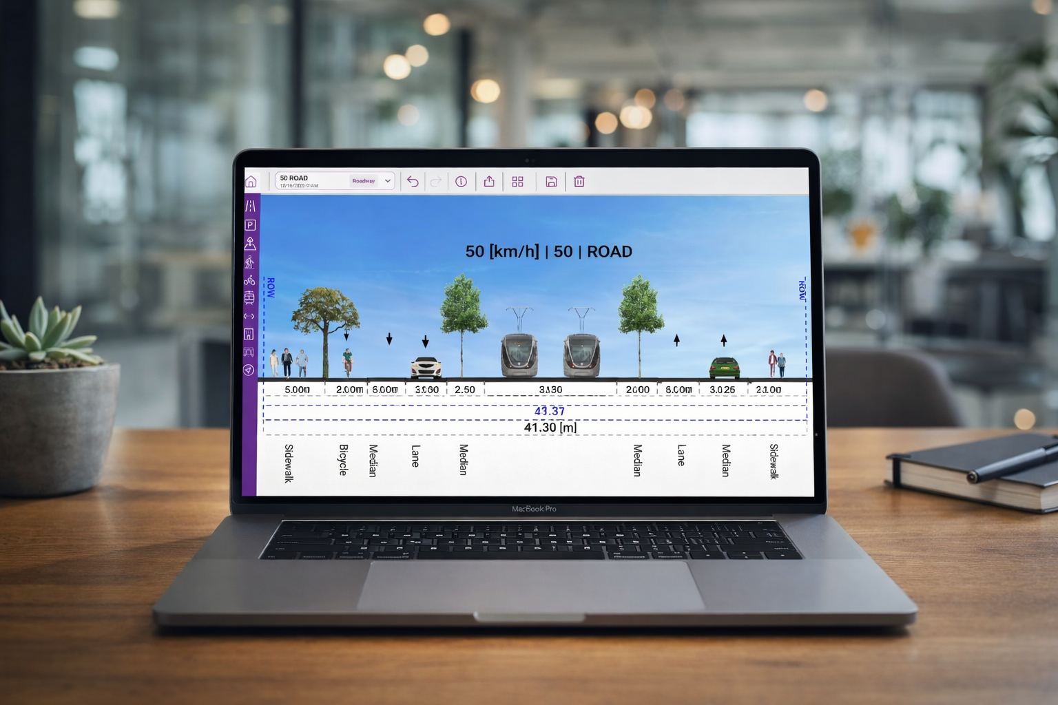
This is where street cross-sections become essential. A street cross-section shows how the right-of-way is divided across sidewalks, lanes, bike infrastructure, medians, planting, parking and other elements. It turns an abstract mobility concept into a visual and measurable street design.
For KCROSS, this is a strong strategic connection. KCROSS is positioned as specialized street cross-section software for engineers, planners and urban design teams, with a parameter-based workflow, professional outputs and export formats including PNG, PDF and DWF.
Key Components of Urban Mobility Planning
1. Accessibility
Accessibility is the ability of people to reach jobs, education, healthcare, public spaces and services. A mobility plan should not only measure travel speed. It should measure whether people can actually reach what they need safely, affordably and reliably.
2. Multimodal Street Design
A city street is not only a vehicle corridor. It is a shared public asset. Urban mobility planning must account for walking, cycling, buses, cars, freight, micromobility, parking, trees, crossings and public realm quality.
3. Public Transport Integration
Reliable public transport is a major part of sustainable urban mobility. Planning teams must consider bus priority, transit stops, transfer points, passenger access, first-mile and last-mile connections and the relationship between transit and street geometry.
4. Active Mobility
Walking and cycling require safe, continuous and comfortable infrastructure. Active mobility planning includes sidewalks, crossings, bike lanes, protected cycling facilities, traffic calming, shade, lighting and safe access to public transport.
5. Corridor Planning
Corridor planning translates network-level goals into specific street segments. This is often where difficult tradeoffs happen. A corridor may not have enough width for every desired feature, so teams need to compare alternatives clearly.
6. Stakeholder Communication
Urban mobility projects often involve public agencies, consultants, residents, businesses and elected officials. Clear visual communication helps reduce confusion and supports better decision-making.
Why Street Cross-Sections Are Critical in Urban Mobility Planning
Street cross-sections are one of the most practical tools in urban mobility planning because they show how policy decisions affect physical space. A plan may recommend safer cycling, better sidewalks or bus priority, but a cross-section shows what that means inside the available right-of-way.
A professional street cross-section can help planning teams:
- Compare design alternatives side by side
- Communicate tradeoffs to stakeholders
- Show how space is allocated between modes
- Test different lane widths and public realm elements
- Prepare presentation-ready visuals
- Align planners, engineers and decision-makers
This matters because urban mobility planning often fails when strategy and implementation are disconnected. A clear cross-section helps close that gap.
The Role of Digital Tools in Urban Mobility Planning
Digital mobility planning tools help teams work faster, compare options more clearly and reduce manual drafting time. Traditional workflows often require multiple tools, manual drafting and repeated graphic updates. That can slow down design iteration, especially when corridor parameters change.
A professional planning workflow should support:
- Fast creation of street alternatives
- Easy updates when dimensions change
- Clear visuals for reports and presentations
- Export-ready outputs
- Collaboration between planners and engineers
- Consistent communication across projects
KCROSS directly supports this type of workflow. According to KCROSS source materials, the software is built around parameter inputs, fast section creation, side-by-side alternative comparison and exports to PNG, PDF and DWF. It is also positioned for transportation engineers, urban planners, landscape architects, architects, municipal agencies, DOTs and consulting firms.
Urban Mobility Planning and Sustainable Mobility
Sustainable urban mobility planning is becoming more important for public agencies and cities worldwide. In Europe, the updated third edition of the SUMP Guidelines was published in 2026 to support cities in developing and implementing Sustainable Urban Mobility Plans. The European Commission also noted that 431 urban nodes under the revised TEN-T Regulation are required to adopt a Sustainable Urban Mobility Plan by the end of 2027.
This reflects a broader shift: mobility planning is no longer only a technical transport exercise. It is part of climate policy, public health, accessibility, economic development and urban quality of life.
For cities, this means the planning process must be more integrated. Land use, transport networks, public space, safety and environmental goals need to be evaluated together. UN research also emphasizes that sustainable urban mobility should focus on connecting people and places, not simply expanding transport infrastructure.
Common Challenges in Urban Mobility Planning
Urban mobility planning can be difficult because cities have limited space, competing priorities and complex stakeholder needs. Common challenges include:
- Limited right-of-way in existing streets
- Conflicts between parking, cycling, transit and pedestrian space
- Slow manual workflows for street design alternatives
- Difficulty communicating technical plans to non-technical stakeholders
- Lack of consistent visuals across planning documents
- Repeated redesign when project assumptions change
- Gaps between policy goals and physical street design
These challenges are especially visible in corridor planning. A city may agree on the need for safer mobility, but every meter of street width requires a decision. That is why fast, accurate and professional cross-section workflows are valuable for mobility planning teams.
How to Improve an Urban Mobility Planning Workflow
A stronger urban mobility planning workflow should move from vision to implementation in a structured way.
Step 1: Define the mobility goals
Clarify whether the project is focused on safety, transit priority, active mobility, congestion reduction, public realm improvement, accessibility or a combination of goals.
Step 2: Analyze the corridor
Review existing street width, land use, traffic patterns, transit routes, pedestrian activity, cycling demand, curb use and safety issues.
Step 3: Create design alternatives
Develop several street cross-section options. For example, one alternative may prioritize bus lanes, while another may focus on wider sidewalks and protected cycling infrastructure.
Step 4: Compare tradeoffs
Evaluate how each alternative affects mobility, safety, public space, cost, feasibility and stakeholder priorities.
Step 5: Communicate visually
Use clear cross-sections and presentation-ready visuals to explain the difference between options. This helps decision-makers understand the physical meaning of each plan.
Step 6: Update quickly
As project assumptions change, the planning team should be able to revise dimensions and regenerate outputs without rebuilding everything manually.
Where KCROSS Fits Into Urban Mobility Planning
KCROSS fits into the practical design and communication layer of urban mobility planning. While a mobility plan defines the strategy, KCROSS helps professionals create the street and corridor cross-sections that communicate how that strategy can work in the real world.
KCROSS is especially relevant for teams that need to:
- Create professional street cross-sections quickly
- Compare corridor design alternatives
- Update section parameters without redrawing from scratch
- Prepare visuals for reports and stakeholder meetings
- Export outputs for planning and engineering workflows
- Work without relying on a slow AutoCAD plus Photoshop process
For urban planners, this supports clearer communication. For transportation engineers, it supports faster design iteration. For municipalities and DOTs, it supports more consistent review and decision-making. For consulting firms, it can improve the speed and quality of proposal and project deliverables.
Best Practices for Urban Mobility Planning Teams
Urban mobility planning is most effective when teams combine strong policy thinking with clear design communication. The following best practices can help:
- Start with people, not vehicles. Focus on access, safety and quality of life.
- Plan for multiple modes. Streets must support walking, cycling, public transport, freight and essential vehicle access.
- Use street cross-sections early. Visual alternatives help teams identify conflicts before detailed design.
- Compare scenarios side by side. Decision-makers need to see tradeoffs clearly.
- Keep outputs professional and consistent. Reports, presentations and public materials should use clear visuals.
- Update plans as assumptions change. Good planning requires iteration.
- Connect mobility goals to physical street space. Strategy becomes actionable only when it can be translated into a real corridor design.
Conclusion: Urban Mobility Planning Needs Clearer Street Design Workflows
Urban mobility planning is about creating cities where movement is safer, more efficient, more sustainable and more connected to everyday life. It requires more than high-level policy. It requires practical tools that help planners and engineers translate strategy into street space.
Street cross-sections are one of the most important bridges between mobility vision and physical implementation. They help teams show how sidewalks, lanes, bike facilities, medians, transit priority and public realm elements fit inside real corridors.
For professional teams working on mobility plans, corridor studies, smart mobility strategies or municipal street projects, KCROSS provides a focused way to create, update, compare and export street cross-sections. Instead of relying on slow manual workflows, teams can use a parameter-based process to move faster from concept to clear, presentation-ready design alternatives.
Ready to improve your urban mobility planning workflow? Explore KCROSS to create faster street cross-sections, compare corridor alternatives and communicate street design decisions with greater clarity.
FAQ
What is urban mobility planning?
Urban mobility planning is the process of organizing how people and goods move through cities. It includes public transport, walking, cycling, road space, freight, accessibility, safety and land-use connections.
Why is urban mobility planning important?
Urban mobility planning helps cities make better decisions about limited street space. It supports safer streets, stronger public transport, better active mobility and clearer long-term infrastructure planning.
What is the difference between urban mobility planning and transportation planning?
Transportation planning often focuses on movement systems and infrastructure. Urban mobility planning is broader because it connects transport with land use, public space, accessibility, sustainability and quality of life.
How do street cross-sections support urban mobility planning?
Street cross-sections show how space is allocated across sidewalks, lanes, bike facilities, medians, parking, transit and public realm elements. They help planners compare alternatives and communicate tradeoffs clearly.
What tools are useful for urban mobility planning?
Useful tools include GIS platforms, traffic analysis tools, public transport planning tools, street design software and street cross-section software. KCROSS is focused on creating, updating, comparing and exporting professional street cross-sections.
Can KCROSS be used by urban planners?
Yes. KCROSS is positioned for urban planners, transportation engineers, landscape architects, architects, municipal agencies, DOTs and consulting firms. It is designed to support professional street and corridor planning workflows.
Does urban mobility planning include smart mobility?
Yes. Smart mobility is often part of urban mobility planning, especially when cities evaluate new technologies, shared mobility, data-informed planning and better integration between transport modes. The key is to connect smart mobility ideas to real street and corridor design.